
The National Weather Service in Peachtree City has released the final snowfall totals from Sunday’s snow storm, and it is interesting to take a look back at what Metro Atlanta and North Georgia experienced on January 16.
Snow Totals
The entire snow total list is available on the National Weather Service’s website, but some of the more notable snow reports include:
- 6″ in Clermont (Hall County)
- 4.8″ in Gainesville (Hall County)
- 4″ in Dahlonega (Lumpkin County)
- 3.4″ on Hog Mountain (Gwinnett County)
- 2″ in Winder (Barrow County)
- 2″ in Johns Creek (Fulton County)
- 1.9″ in Lawrenceville (Gwinnett County)
- 1.0″ in Douglasville (Douglas County)
- Trace in Newnan (Coweta County)
Sleet/Freezing Rain Totals
In addition, sleet and freezing rain was observed during the storm. These reports include:
- 0.25″ in Five Points (Madison County)
- 0.12″ in Rabbitown (Hall County)
- 0.10″ in Oxford (Newton County)
- 0.10″ in Athens (Clark County)
Strong Wind Gusts Throughout the Storm
The storm exhibited signs of strengthening as it moved over North Georgia, and as a result, strong winds were observed throughout the life of the storm.
The entire list of wind gusts is available on the National Weather Service’s website, but here are some notable reports:
- 54 mph at the Atlanta Airport
- 53 mph in Dahlonega (Lumpkin County)
- 52 mph in Gainesville (Hall County)
- 46 mph at the Peachtree DeKalb Airport in Chamblee (DeKalb County)
- 44 mph in Cumming (Forsyth County)
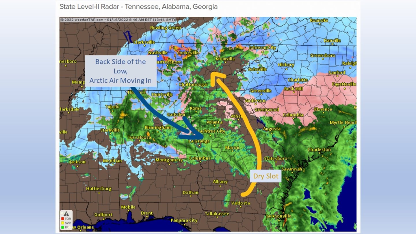
Recapping the 3-D “puzzle” of the storm
Leading up to, and throughout our storm coverage on Sunday, I used the analogy of “this storm is a Rubiks Cube” to describe what I was experiencing in my analysis. It’s an analogy, and not an actual technical term. But it’s the best way I can convey to you how complex this system was!
Below is the 10am Sunday Skew T diagram, which is generated when the National Weather Service lifts weather balloons into the atmosphere.
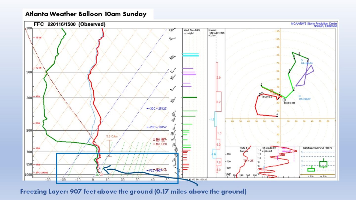
The Skew T diagram shows the air temperature, dew point, winds, etc from the ground to high up in the atmosphere.
Over Metro Atlanta at 10am Sunday, the air was below freezing until about 900 feet above the ground. That’s why the snow was able to fall even though the air temperature was above freezing -- the snowflakes were melting but surviving the 900 feet of 33-37 degree temperatures.
Thank You for your Open Mics and Social Media Reports!
Your “ground truth” storm reports helped me stay on top of the storm’s progress and provide accurate weather information on Sunday! Please continue to share with me what you see outside during stormy weather: Radar imagery and weather instruments can give me a good picture of the storm, but your “ground truth” reports help me correlate the weather data with the actual observations across Metro Atlanta and North Georgia. Keep them coming!
Share your Winter Precip Reports with Me!
Facebook: Christina Edwards WSB
Twitter: @ChristinaWSBwx
©2022 Cox Media Group


