
Models and humans can and do have busted forecasts, even looking ahead just 4-12 hours, it’s much more rare for a total bust short-term and more common the further into the future you attempt to peer. This of course is well known knowledge to most people once they reach age six or so.
Below is an interesting recent case in the Mid-Atlantic region January 19-20:
Short-range mesoscale model 12-hour forecast of snow, in reality no snow, all rain for entire event in VA/MD/DE/DC/DE.

The model simply miss-handled the polar air, it moved the cold air in way way too fast and too far. It came but not until the precip was gone. The cold air came in much slower than the models indicated.
Yesterday (Friday, January 21st 2022) in Metro Atlanta a few spots got spits of flurries, sleet or drizzle but it was of no consequence and most places stayed dry.


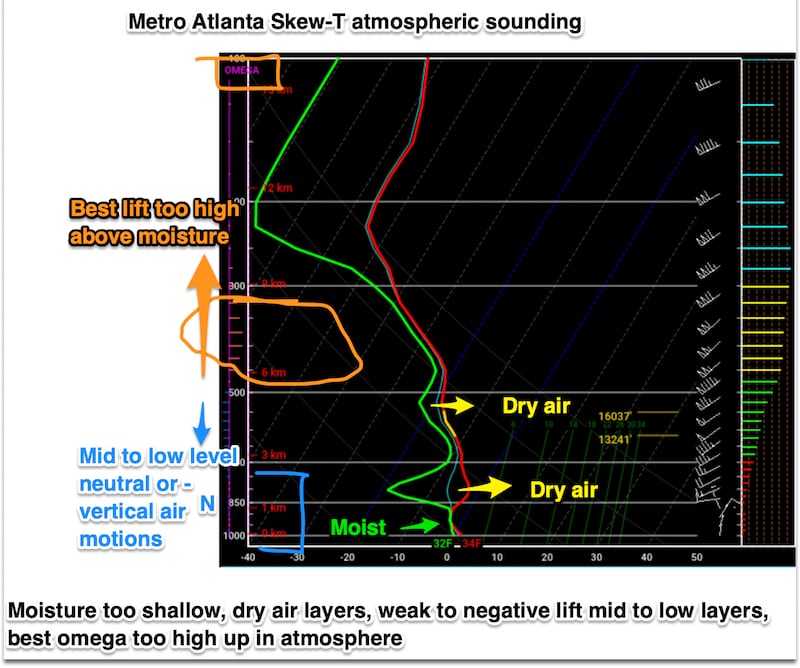
Most of the precipitation evaporated before reaching the ground in most of the Atlanta area. WHY?
Because the moist air was close to the ground, and high-up, but there was a layer of DRY AIR in-between that “ate up” the precip as it fell. On top of that, most of the best upward air motion (lift) or omega was in layers away from the moisture, high up, as seen in the vertical sounding (Skew-T thermodynamic diagram):
Downstate farther South and East of Metro Atlanta the conditions were more favorable for accumulating snow/sleet:

Hence:

ACTUAL:

Last Monday, January 17th in the morning I sent out this Tweet. And pinned it to the site. I never needed to send out another Tweet on the subject showing snow/ice maps or anything else nor did I ever do a blog about it because I never felt it was warranted for Metro Atlanta:

Good reasons for not posting snow/ice maps far in advance. Examples:
I take the below-maps out of time and context and without showing date or year for a reason...

JUST SAY NO TO COMPUTER MODEL MAP NONSENSE.

Think about it...why don’t they ever post/show this kind of snow map for the distant future? Has just as good a chance of being right!:

People really shouldn’t share or show long-range model “snow” maps. It’s foolish, unnecessary, unhelpful, hype for desperate need for ratings, likes, hearts, retweets and shares. Please say no to this. It can and should wait. The public and the meteorology/broadcast news business and social media will all be better off.
Beyond 3 days it’s best to use ensembles and multi-model means. But even ensemble snow/ice maps should be shown or shared only rarely and judiciously, and then only with explanation/interpretation imo.

Remember my old saying, it’s meteorology NOT modelology. I guess all they teach in college now is to point and click models instead of how to analyze the atmosphere and interrogate model products with a deep dive.
Faces and feelings when I see snow/ice map teases being shared or shown for a distant and/or iffy event on models:


Follow me on Twitter @MellishMeterWSB.
©2022 Cox Media Group


