
This blog post is not about specific forecast details for each of the next 5 to 10 days, I provide that elsewhere as always across all platforms digital and over the air.
This is about the chance of a thunderstorm with damaging wind or hail odds the next couple days and again Easter Sunday.
I’ve already posted several blogs on this topic along with the chance of a cold snap to follow so you already had a heads up if you’re following along. You miss a blog or a tweet you miss a lot.
NO severe weather concern for today, Tuesday.
A low-end “MARGINAL” RISK (1/5) for an isolated severe thunderstorm tomorrow Wednesday:
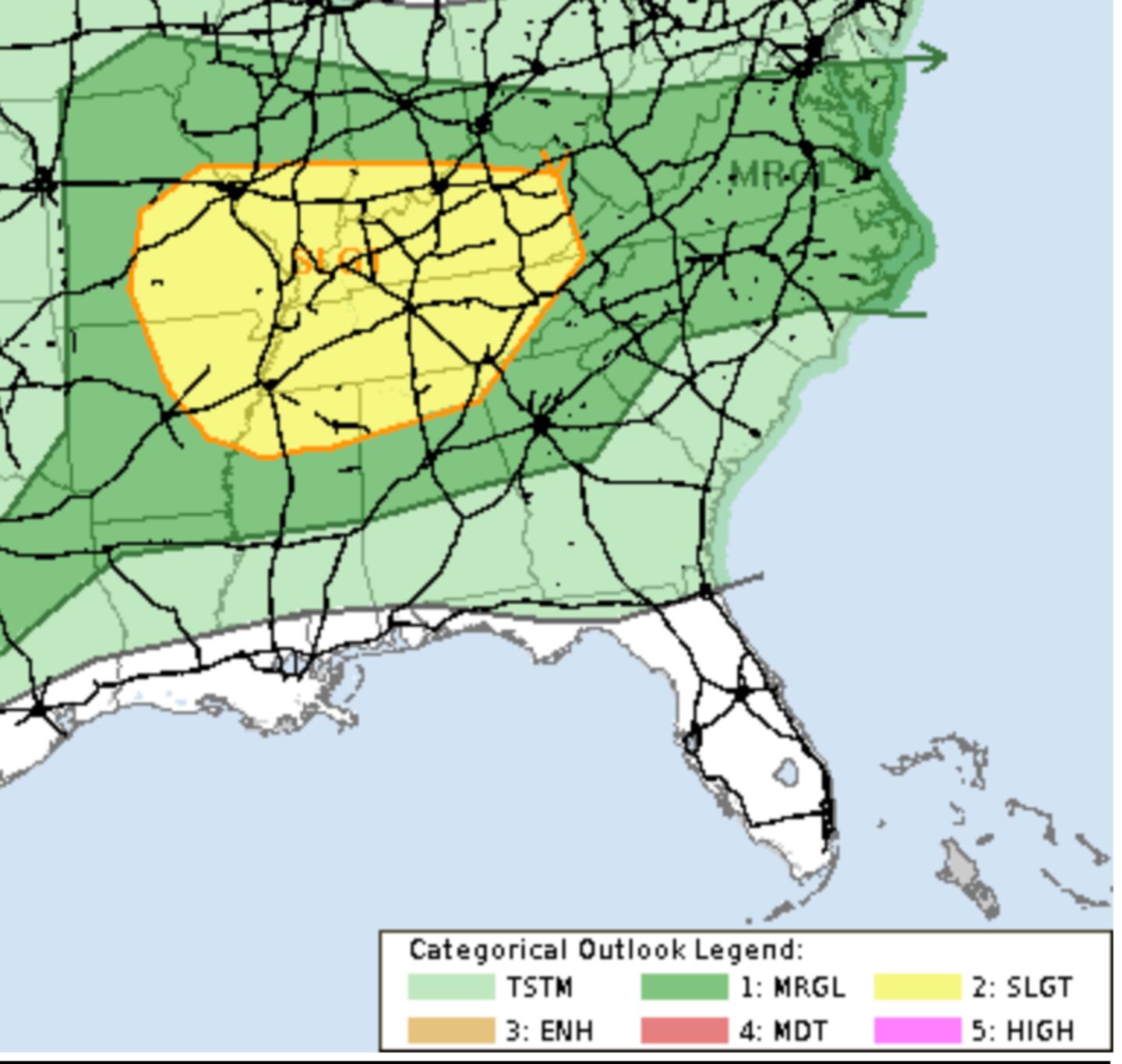
Same for Thursday, a MARGINAL RISK (1/5) for an isolated severe thunderstorm:

ZERO RISK Friday-Saturday:

The big question mark is Sunday as periods of rain are expected Saturday night through Sunday night with 1-2 inch totals on average.
But there is concern for severe weather as well. Here is the NOAA/NWS Storm Prediction Center discussion on the matter:

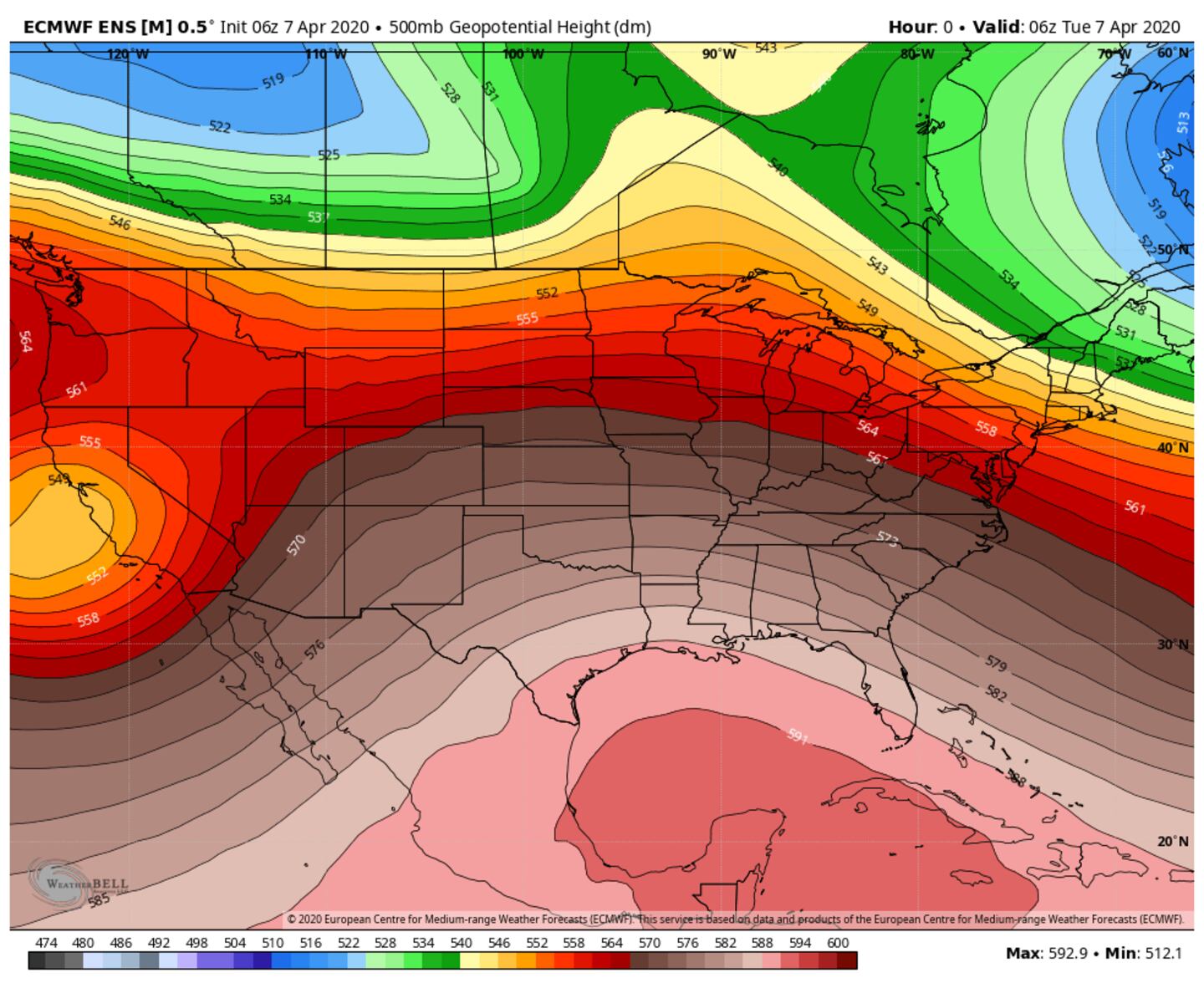
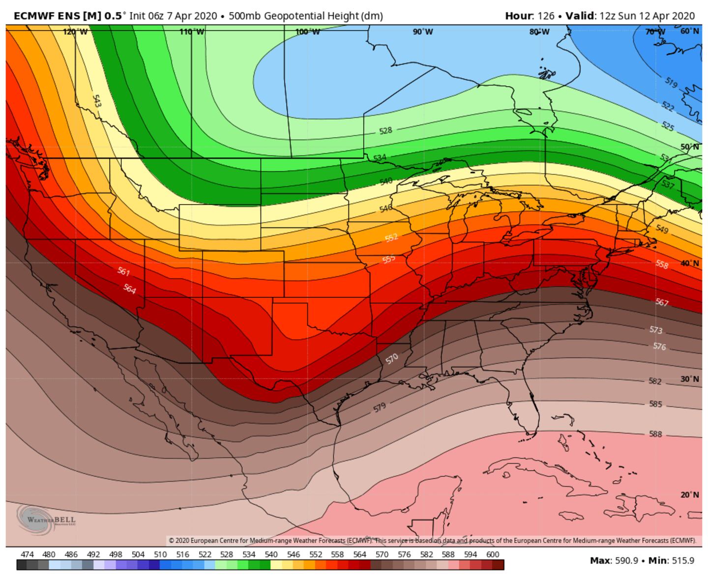
The system for Sunday/Monday in the Southeast is heading into Southern California today, you can see it in the 500mb ~18,000 foot jet stream as a closed upper level low in the charts below, it slowly ejects to the East between now and the weekend:

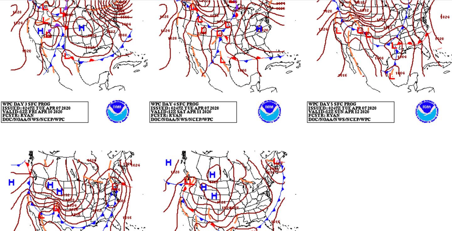
The corresponding surface weather chart depictions days 3-7:
The ensembles have a robust signal for the set-up and the time of year is a match for climatology. In other words, tis the season.
The numerical variants have been depicting a favorable jet stream pattern for significant lift or synoptic scale upward vertical motion (strongly rising air) in the atmosphere from surface to aloft as jet streaks (concentrated pockets of strongest winds within the general jet stream) spread out aloft. The equations place a good part of the Southeastern U.S. in a favorable jet stream quadrant for severe weather.
Following Quasi-Geostrophic (QG) Theory we can project the kinematics of the situation to approximate the areas of concern as we add a look at upper level diffluence and divergence as streamlines spread out:


Indications are for a jet stream of 92-125 MPH at 500mb. The darkest colors indicate the location of the jet streak or jet “max”. I’ve highlighted the 4 quadrants and the most favorable for strong upward motion and highlight the streamlines spreading apart downwind of the upper level trough of low pressure.
Higher up to the main jet stream core we see the model simulation showing even stronger winds and a dual jet streak pattern for couple jet stream dynamics as the farther North and farther jet streaks work in tandem to provide synoptic scale enhanced upward air motions:


Plenty of vorticity embedded within the jet stream flow is depicted by the ECMWF model which is also favorable late Sunday into early Monday:

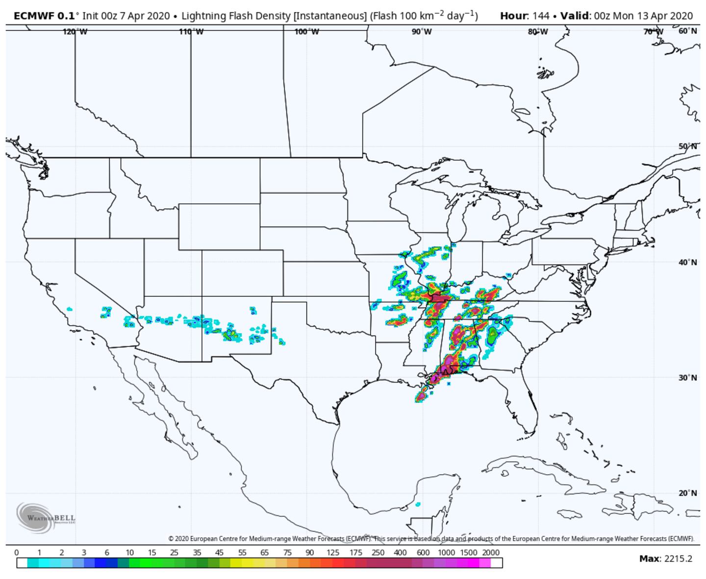
These strong jet stream dynamics indicate favorable QG forcing for ascent, but the devil is in the details as to how big a severe threat and where. A model guesstimate below from the ECMWF end of day Easter Sunday:
I DO NOT present this information as some kind of OMG alarm.
It is too far in the future to know how this system will play out. This would be true any time, but particularly this year as I’ve beat the dead horse on how poorly models have been performing beyond 3-5 days for a couple years now in the new weather and climate regime.
Either way strong jet stream kinematics are just ONE single factor to severe weather, there are hundreds of others. And even this model with its favorable jet stream shows some of the other parameters such as thermodynamics to be much less favorable.
Other models keep the severe weather risk to our South. My current thinking (current is the key word) supported by the analog method, is it will end up worse to our West and to our East both North and South but I could change my mind by the time we get closer.
Much will depend on the strength and timing of cyclogenesis to our West and whether-or-not Atlanta gets in the warm sector with deep layer shear or if rain cooled air keeps the warm front closer to the Gulf with soaking rains and convection there robbing points North.
We will obviously be able to fine tune the forecast with each passing day.
It still looks like a couple shots of brief colder air over the course of the next 10 days, I don’t see a freeze but frost can’t be ruled out, details TBD.

For more follow me on Twitter @MellishMeterWSB.


