

Just in time for the weekend, unsettled weather will move through the Metro Atlanta area, potentially bringing strong to severe thunderstorms to the region.
Friday’s Outlook
Friday will be the best day to be outdoors, as the stormy weather is not anticipated to arrive until late in the afternoon through evening hours. It will still be hot, though, as afternoon temperatures climb into the mid 90s.
The animation below illustrates the Futurecast Hour-by-Hour Radar for Friday afternoon and evening.

Saturday’s Outlook
Leftover showers and storms from Friday night will likely still be around for Saturday morning, then a break in the storms will occur through the early afternoon. Enough sunshine will peak through the clouds to heat temperatures to the upper 80s to low 90s.
However, another round of storms will develop late Saturday afternoon and roll through Saturday evening. If you are attending any outdoor events like the World Cup Watch Parties, be sure to keep an eye on they sky and head indoors to safety when the storms roll through.
Event organizers should monitor the weather conditions, as some of these storms may be capable of producing damaging gusts and torrential downpours.
The animation below illustrates the Futurecast Hour-by-Hour Radar for Saturday morning through the evening hours.

Sunday’s Outlook
Very similar to Saturday, morning rain showers and storms may lurk in the Metro Atlanta area, followed by a few hours of afternoon sunshine.
However, round of heavy rain and thunderstorms will roll through Sunday afternoon through the evening hours, producing some areas of damaging winds and heavy downpours.
What is up with the severe weather during the summer?
Some of the most damaging storms happen in the summer time.
Afternoon thunderstorms often produce downbursts, which look like big drops of rain-cooled air and precipitation that can level numerous trees in a short amount of time. Often, a severe thunderstorm warning is issued for “pop up” storms that are capable of downburst wind damage.


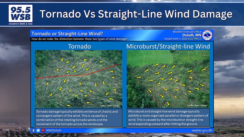

In addition, any land-falling tropical systems that move through Metro Atlanta bring the potential for quick spin up tornadoes. The extra rotation in the atmosphere from the tropical system encourages tornadoes to develop here at the ground level.

Finally, large storm clusters can produce a wide swath of straight line wind damage, some of which can level trees and powerlines. These storm clusters appear on the radar as a line of storms marching across town, and they can prompt severe thunderstorm watches and warnings.
Share Your Storm Photos with Me!
Facebook: Christina Edwards WSB
Instagram: ChristinaWSBwx
Twitter: @ChristinaWSBwx
©2026 Cox Media Group