
It is not unusual for numerical models to rush a jet stream pattern change showing it coming faster than it does in reality, and so it may be that the SSW blocking change to the Polar Vortex and subsequently the jet streams will still come East of the Rockies in the future, but first we get a warm-up.
The entry of a polar air mass or even a cAK air mass into the U.S. may be a case of delayed but not denied.
As mentioned in a previous blog the numerical equations are struggling with the volatile and active flow across the Pacific from Asia across Canada the U.S. and Europe which leads to flip flops as you can see in the 500mb jet pattern projection from the Canadian model ensemble output:


But the Stratosphere at the base of “outer space” the warming and PV split suggests a colder shift eventually should occur:


ANALOGS VS. CPC:


It doesn’t help model or human forecaster performance when the ocean-atmosphere is out of whack from past history as it is yet again this year. The Pacific Ocean is in a LA NINA state, but the jet stream patterns have been behaving as if there is an EL NINO state. There are some years or parts of years when the long-range modeling 10-30 days do pretty well on the pattern when the hemispheric atmosphere drivers are stable, this is not one of those, they are unstable.
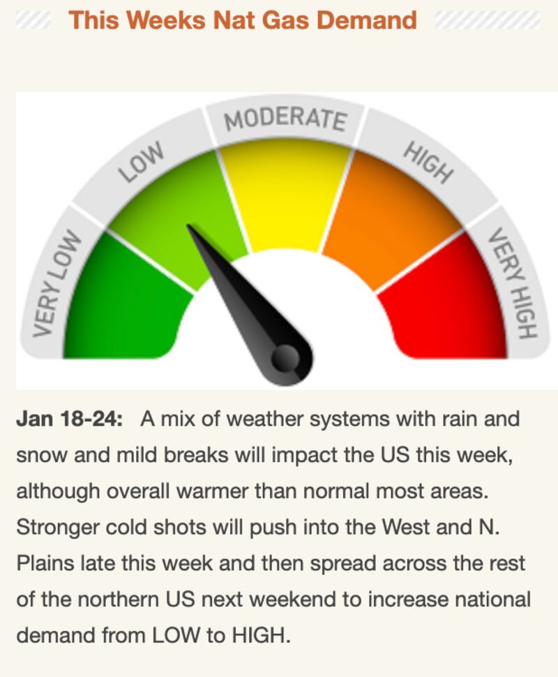
Remember from all the prior posts the “window of opportunity” period was second half of January into February, well we JUST NOW started the second half of January.
The opportunity for an increase in “Texas Pan handle storm tracks and Miller A and Miller B storm types looks to exist for the last week of this month and opening week or two of February, some have suggested if it comes it could last through March but I am not willing to go that far yet. I have to at least see signs of cross-polar flow first and I am not confident enough in that yet.


The tug of war I’ve written about in many post the past month continues between warmer and colder signals. The AO/NAO/WPO/EPO/MJO/PNA continue to give mixed signals fighting each other with opposite signs indicating a lot of instability in what the future will bring. Models are really having a lot of problems with this unique teleconnection set up conflicting with one another.
This weather battle will shift our precipitation as we go from a long period of below-normal precipitation to a wetter pattern with more up and down temperatures in the short to medium range period, but more than usual I can’t trust any model specifics beyond 7 days.
It’s a frustrating (for winter lovers) wait and see game where we could end up with bupkis or go from no sign of anything to suddenly seeing a cold wave and/or snow or ice.
Cox Media Group


