The risk to the extended outlook comes from numerous Typhoons in the West Pacific Ocean which can alter the behavior of the downstream weather pattern over the United States depending on how strong they get and whether they go West or recurve North into the jet stream. So the mid week 2 period could see swings in the model data from what we see as I write this. In other words the next 5-10 days, especially next week and beyond is low confidence.
Either way the real scorching heat will stay to our North and West whether we get a big warm-up or not.
Notice how the upper-air pattern changes over the country including our area as jet stream dips (troughs) and rises (ridges) alternate switching temperature patterns from below normal to above normal and then back again as we move through the rest of September.


7-DAY TEMP DEPARTURE FROM NORMAL SEPT 14-20 HIGHS AND LOWS AVERAGE OF 7 DAYS TOGETHER:

SEPT 21-27 TEMP DEPARTURE FROM NORMAL HIGHS AND LOWS AVERAGED TOGETHER:

This is consistent with signals from the forecast MJO into PHASES 4/5:

IF CORRECT this indicates a GRADUAL warming trend culminating in a CHANCE OF 90º in the extended medium range outlook around September 22nd give or take a couple days. The ECMWF ENSEMBLE probability guidance shown below indicates an 80-90% chance of a high of 90 sometime near this date.


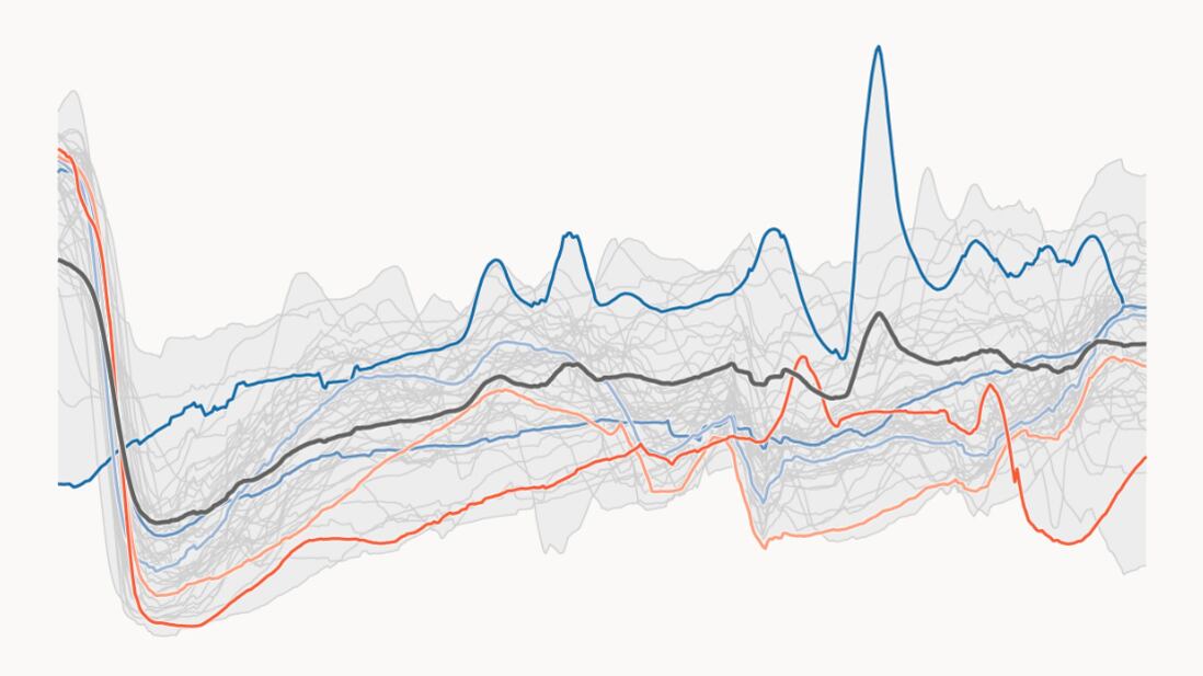
BLEND OF MODELS TEMPERATURE GUIDANCE IN COBB COUNTY:

The humidity will also creep back up, BUT NOT to very high levels in this warm-up thankfully.
As I Tweeted days ago before the cool low humidity air mass arrived it would be followed by a warming trend and an increase in sunshine along with a long dry spell. The next decent rain chance may not be until 12 days from now give or take a few.
7-DAY RAINFALL FORECAST AMOUNTS:

ENSEMBLE 3 MODEL BLEND RAIN % DEPARTURE FROM NORMAL SEPTEMBER 21-27TH:

LET ME REITERATE, the uncertainty produced by not one but three typhoons in the West Pacific makes for a lower than normal confidence in the return of heat to our region. IF one or more of the typhoons are stronger than expected or recurve more to the North than expected then our region will probably NOT get that warm because that would shift the jet stream ridge more to our West.
Some very strong amplified flow showing up on the longer range progs that likely stem from the Aleutian low (pumped up strong by Pacific recurving typhoons) that sends a cascade effect downstream, meaning tall western ridge, and deep eastern trough. You can see for yourself in the map below the CHANGE OF LOCATION of the troughs and ridges when/if a Typhoon goes North in the West Pacific.
Model change from 24 hours ago, switched to cooler East hotter West. So a brief return of summer-like temps is not written in stone by any means but IS VERY possible.

EVEN IF we do get a big warm-up, another cool-off is expected (approximately Sept 27-Oct 10) with another East Coast trough forecast to follow any warmer ridge by the end of this month and start of October:


For more frequent weather info follow me on Twitter @MellishMeterWSB.
©2022 Cox Media Group


