
Hurricane Agatha formed in the Pacific Ocean in late May, and it made landfall along the coast of Mexico on Monday, May 30.
4pm CDT 30 May - #Hurricane #Agatha has made landfall just west of Puerto Angel, Mexico, with maximum sustained winds of 105 mph.
— NHC Eastern Pacific (@NHC_Pacific) May 30, 2022
Since record keeping began in 1949, this is the strongest hurricane to make landfall in May along the Pacific coast of Mexico. pic.twitter.com/dUraseRoDe
Agatha’s storm structure battled the mountainous terrain of south Mexico, and eventually, Agatha dissipated.
However, the remnants of Agatha’s storm structure will eventually drift east and merge into the Gulf of Mexico.

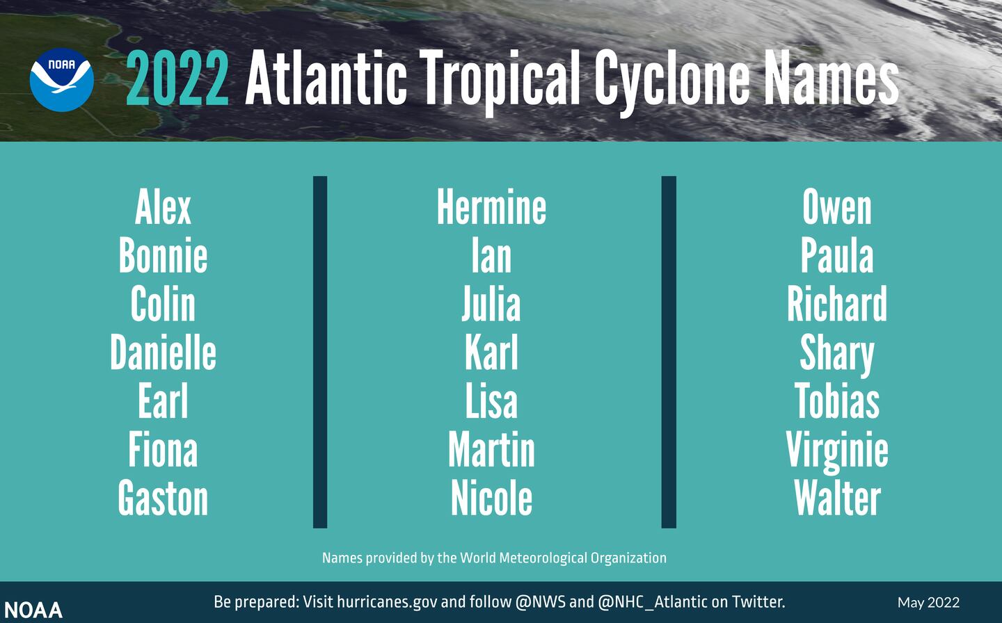
There is a possibility that these remnants may generate into a new tropical depression (sustained wind speeds up to 38 mph) or even a tropical storm (wind speeds 39 mph to 73 mph). If the system strengthens into a tropical storm, it would receive the name ‘Alex’, which is the first name of the 2022 Atlantic Basin Tropical Storm and Hurricane Names.
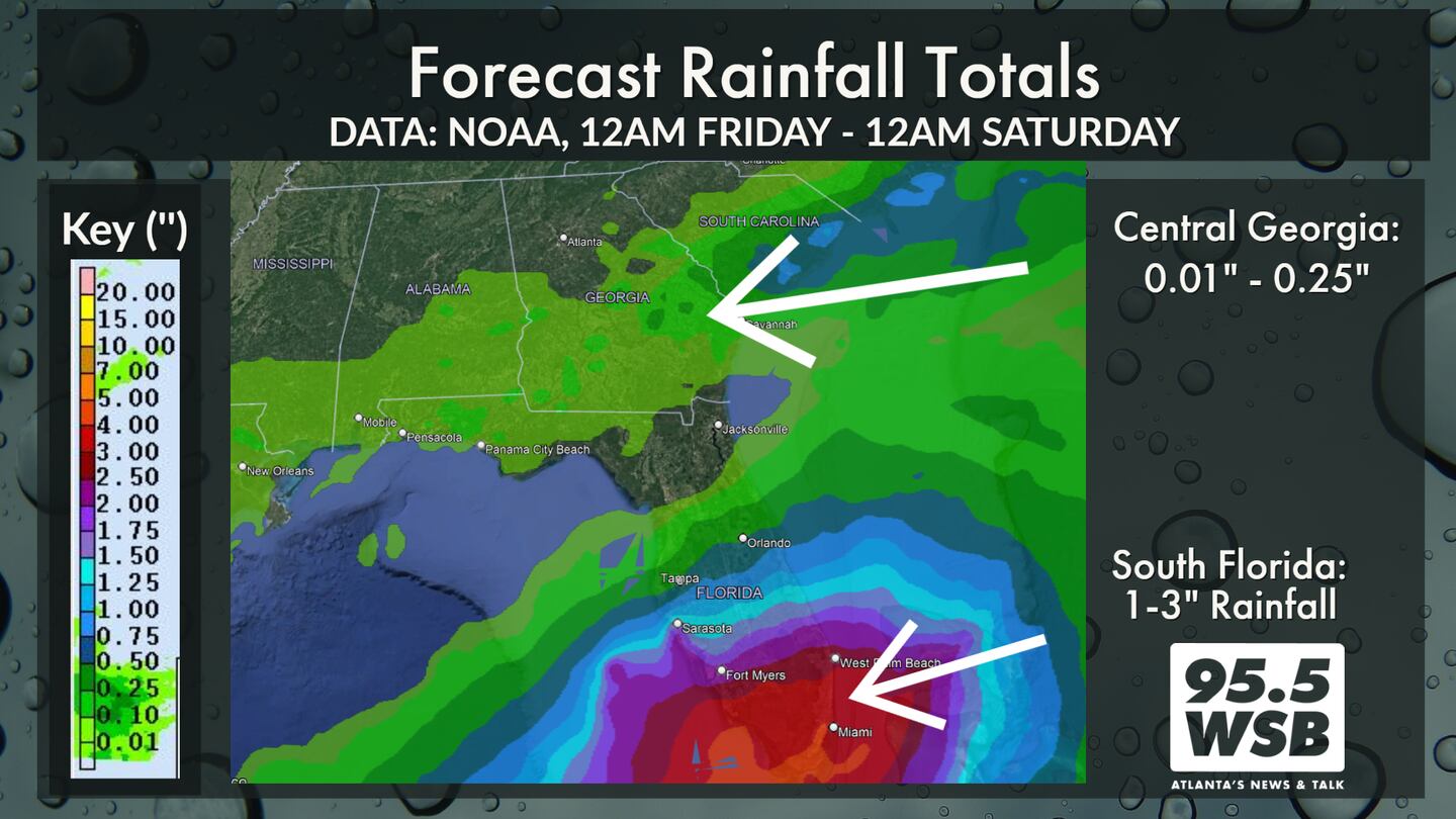
The system is expected to move east through the Gulf of Mexico through the weekend, with a forecast path that moves over south Florida. The tropical system is not expected to move north until it is east of Florida, due to a cold front that will “block” the system from moving north.
As much as 1-3 inches of rainfall is possible in South Florida, including Fort Meyers, West Palm Beach, and Miami. The tropical system is not expected to bring much rainfall to the state of Georgia.
Tropical Tidbits: Why it’s ‘Alex’ and not ‘Agatha’
Admittedly, there are a lot of technicalities in meteorology, and the Agatha/Alex naming convention illustrates one of them.
A tropical system is considered a “wave” when it has an open area of circulation. In other words, there are no closed millibars on a pressure map associated with the tropical wave..
Once a tropical system has a closed center of circulation, it is considered to be organized and receives a designation of a tropical depression (sustained winds up to 38 mph), a tropical storm (sustained winds 39 mph to 73 mph), or a hurricane (sustained winds 74 mph or greater).
There have been hurricanes and tropical storms that weakened in the past and regenerated again, maintaining their “name” along the way. This is because the tropical systems were able to maintain their closed center of circulations.
There have also been systems that crossed from one ocean basin to the other and retained their name. One example of this is 2016′s Hurricane Otto, which moved from the Gulf of Mexico (which is in the Atlantic Basin) over Central America and reemerged in the Pacific Ocean. Otto maintained its center of circulation during the cross over, which is why it kept its name from one ocean basin to the other.
In the case of Hurricane Agatha, the system quickly fell apart as it moved over Mexico and no longer exhibited a closed center of circulation. A cluster of thunderstorms remains in the vicinity of where Agatha made landfall, but the storms are unorganized..

Once this cluster of storms moves over the Gulf of Mexico, it is expected to re-organize and generate a closed center of circulation around the strengthening low pressure system. At this point, the system would either become a tropical depression or Tropical Storm Alex.
Connect with Me!
Facebook: Christina Edwards WSB
Twitter: @ChristinaWSBwx
©2022 Cox Media Group


