

The ninth named storm of the Atlantic Hurricane Season formed this morning, and Tropical Storm Isaias is forecast to strengthen to the first hurricane this season late tonight into early tomorrow morning.
The animation below illustrates the infrared satellite imagery as Isaias swirls in the Gulf.

Use the Interactive Tropical Tracker below to track the potential strength and forecast path for Isaias.
Isaias’ Impacts on the Southeast
Isaias is forecast to make landfall along the coast of Mobile to Pensacola as a hurricane late Friday into early Saturday morning.
The center of Isaias is then forecast to move through west Alabama, potentially impacting the timing of play for the Georgia vs Bama game, currently scheduled for 3:30 pm Saturday afternoon in Tuscaloosa.
The image below illustrates the Futurecast Wind Gusts for west Alabama through 2pm Eastern/1pm Central time on Saturday afternoon.
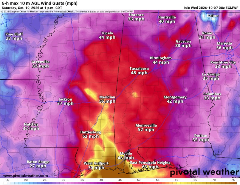
Any Georgia Bulldog fans intending to travel to Tuscaloosa should monitor the forecast for central Alabama, as this is an area that will experience worse conditions compared to North Georgia. These impacts include:
- Stronger wind gusts in central Alabama (as high as 40-50 mph)
- Heavier rainfall totals
- Greater risk for quick-spin up tornadoes within hurricane’s rain bands
Isaias’ Impacts on Metro Atlanta
In summary, the impacts on Metro Atlanta are as follows:
- Breezy conditions Saturday and Sunday, wind gusts 30-40 mph
- Moderate to heavy rain showers, as much as 1-2 inches through Sunday evening
- Isolated tornado threat (lower threat further east)
Wind Impacts
As Isaias moves inland, high pressure will develop over New England. Air will flow clockwise around the high and continue to flow down the Appalachian Mountains.
Air will “wedge” up against the mountains, creating cooler than usual temperatures on Saturday as afternoon highs remain in the upper 60s for Metro Atlanta.

This pattern, known as “The Wedge”, will push the core of Isaias further west into Alabama and Mississippi.
As a result, the bulk of the strongest winds will occur further west, however Metro Atlanta can still expect breezy conditions Saturday and Sunday. The animation below illustrates the Futurecast Wind Gusts for Metro Atlanta.

Rain Impacts
While the core of Isaias will remain west of Metro Atlanta, the storm will still be wide enough to swirl rainbands into North Georgia.
The animation below illustrates the Futurecast Radar imagery for this weekend.

As much as 1 to 2 inches of rainfall is to be expected between Saturday morning through Sunday evening.

Tornado Threat?
When a landfalling tropical system moves through the Southeast, meteorologists always keep an eye on the upper-right quadrant for potential spin up tornadoes.
At this time, the tornado threat is low, but not zero, for North Georgia, and the tornado threat will adjust higher-vs-lower as the core of Isaias moves ashore this weekend.
Bottom line, stay tuned to 95.5 WSB for updates on the forecast through the week and into the weekend.
Connect with Me!
Facebook: Christina Edwards WSB
Instagram: ChristinaWSBwx
©2026 Cox Media Group