

Hurricane Isaias continues to strengthen and become more organized as it swirls in the Gulf today, becoming a Major Category 3 Hurricane as of 8:20am EDT Friday with maximum sustained winds of 120 mph.
The animation below illustrates the infrared satellite imagery for Hurricane Isaias as of Friday morning.
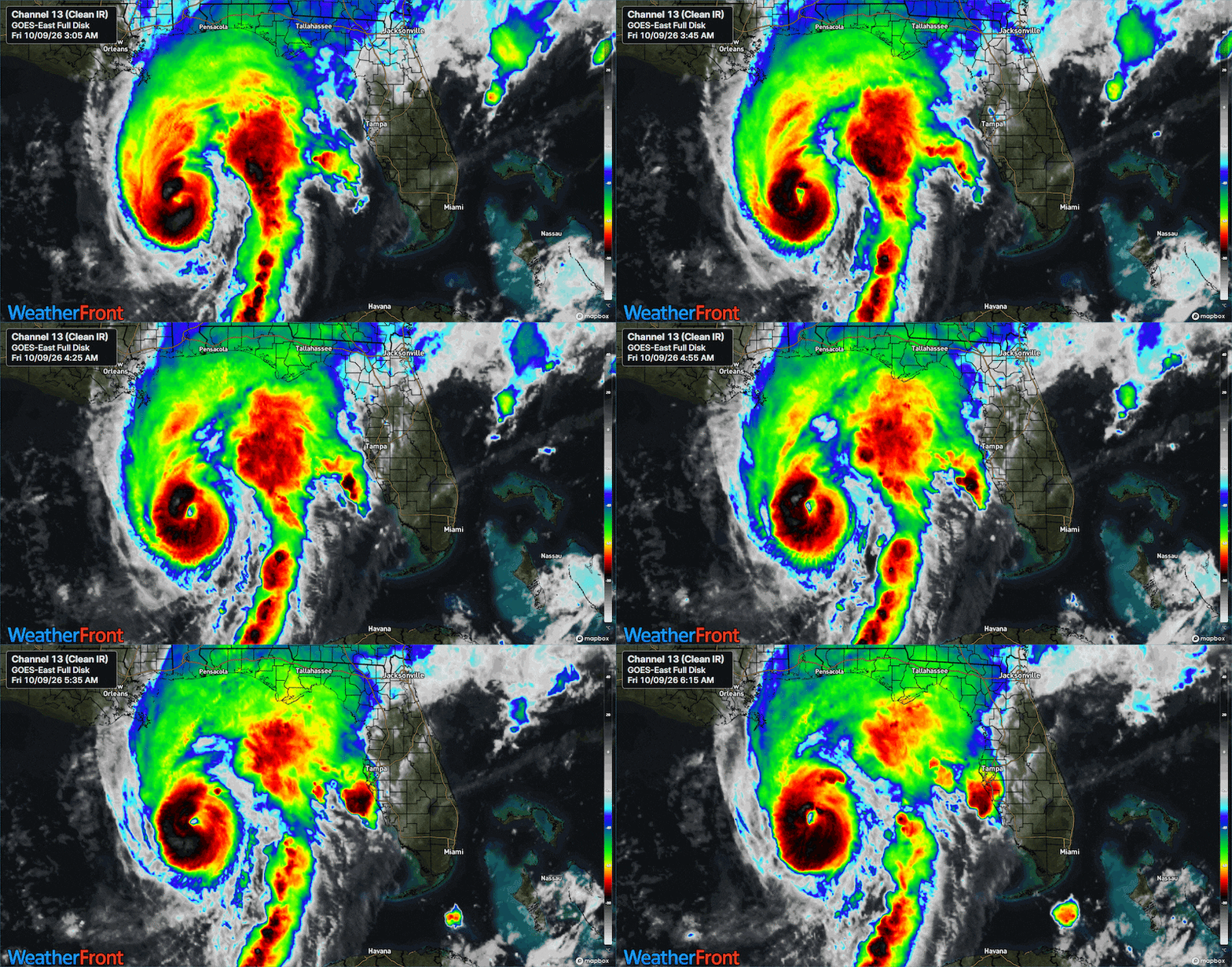
Isaias is forecast to make landfall between Mobile, Alabama and Pensacola, Florida sometime this evening. The hurricane will likely make landfall as a strong Category 2, if not a Major Category 3.
Use the Interactive Hurricane Tracker below to track Hurricane Isaias.
Isaias’ Impacts on Metro Atlanta -- Greatest Impacts Begin After Midnight Saturday
In summary, the impacts on Metro Atlanta are as follows:
- Breezy to strong wind conditions all day Saturday. Wind gusts 40-45 mph, some gusts as high as 50+ mph in higher elevations of Bartow, Cherokee, North Fulton, and Forsyth counties. North Georgia Mountains may experience wind gusts as high as 60 mph.
- Moderate to heavy rain showers Saturday, as much as 2-4 inches late Friday night through early Sunday morning
- Quick spin-up tornado threat in Middle Georgia through southern Metro Atlanta
Wind Impacts
A High Wind Watch is in effect through Saturday night for Metro Atlanta.

As Isaias moves inland, high pressure will also strengthen over New England.
Air will “wedge” up against the mountains, creating cooler than usual temperatures on Saturday as afternoon highs remain in the upper 60s for Metro Atlanta.
As a result, the bulk of the strongest winds will occur further west in the Birmingham, Alabama area.
However Metro Atlanta can still expect windy conditions Saturday as a pressure gradient develops between Isaias (the Low) and the mountain High.

The winds will be strongest in North Georgia -- including Metro Atlanta -- on Saturday, with wind gusts as high as 40 to 45 mph.
North Metro counties -- including Bartow, Cherokee, North Fulton, and Forsyth -- may experience some gusts as high as 50+ mph in higher elevations of these counties.
North Georgia Mountains may experience wind gusts as high as 60 mph.
The animation below illustrates the Futurecast Wind Gusts for Metro Atlanta Saturday morning through Sunday afternoon.

Rain Impacts
A Flood Watch is in effect for Metro Atlanta through Sunday morning.

While the core of Isaias will remain west of Metro Atlanta, the storm will still be wide enough to swirl rainbands into North Georgia.
The majority of the rain will fall just after Midnight Saturday morning through Saturday night, tapering off early Sunday morning.
The animation below illustrates the Futurecast Radar imagery for Saturday through Sunday morning.
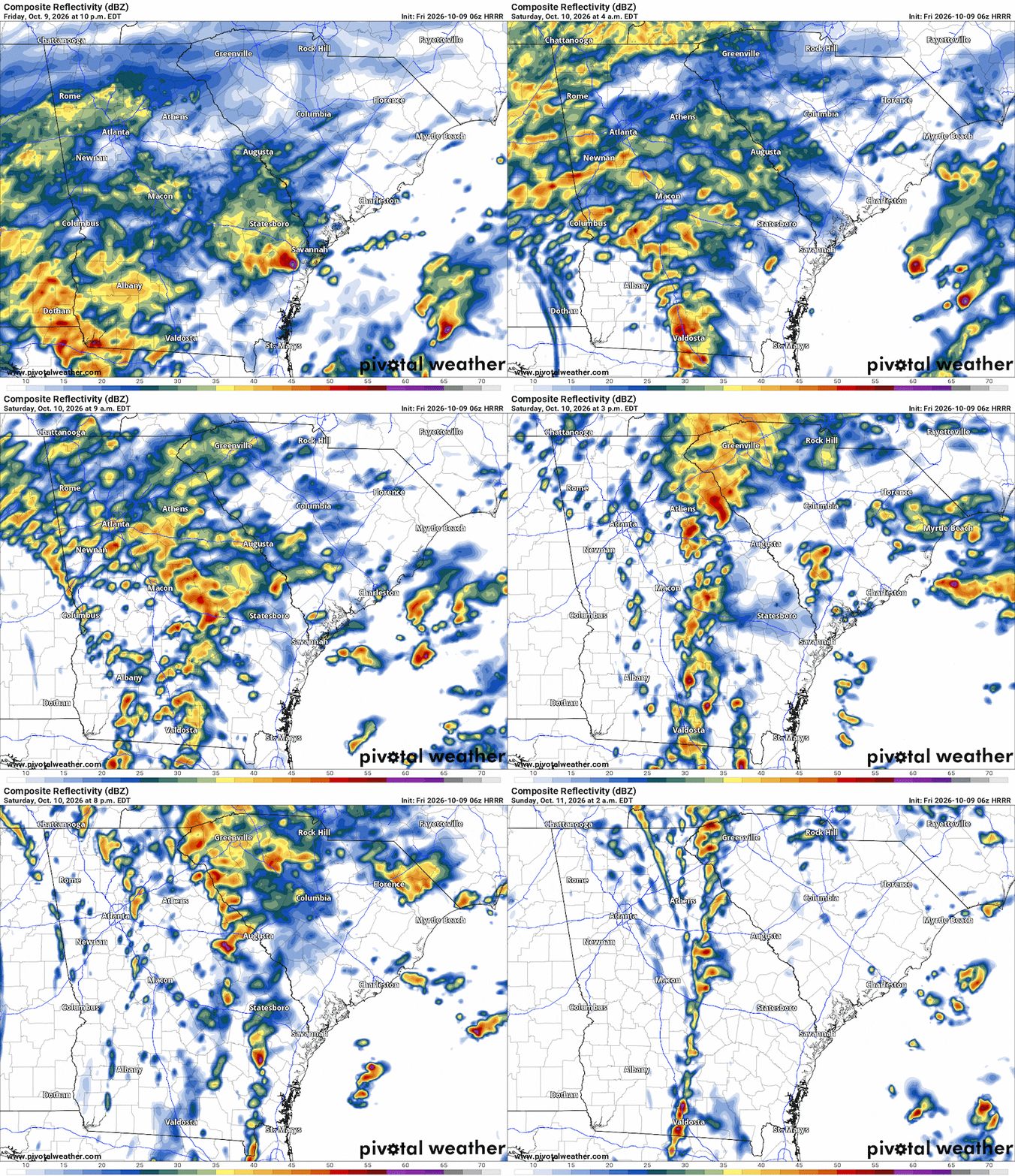
As much as 2-4 inches of rainfall is to be expected between Saturday morning through Sunday evening.

Tornado Threat?
When a landfalling tropical system moves through the Southeast, meteorologists always keep an eye on the upper-right quadrant for potential spin up tornadoes.
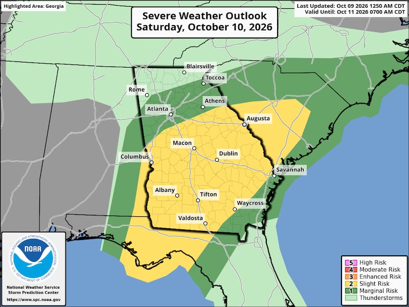
At this time, the Storm Prediction Center has outlined a Marginal Risk of severe weather for the majority of Metro Atlanta and North Georgia.
A Slight Risk for severe weather is outlined for the southern Metro area, and for much of southwest Georgia.

Bottom line, stay tuned to 95.5 WSB for updates on the forecast through the week and into the weekend.
Connect with Me!
Facebook: Christina Edwards WSB
Instagram: ChristinaWSBwx
©2026 Cox Media Group